Description
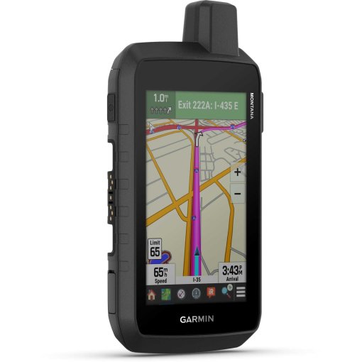
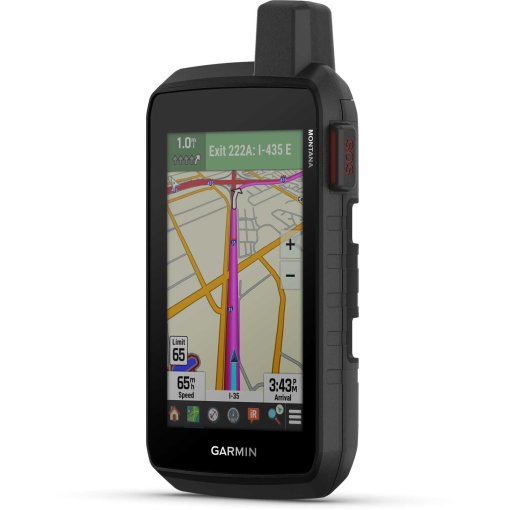
Garmin Montana 710 Handheld Navigation Device
Robust handheld device with touch display
With routable maps for roads and trails, the Montana 710 delivers advanced outdoor features in a rugged 5-inch format. The handheld device is ideal for navigation on foot, by bike, kayak, off-road vehicle and more.
Highlights of the Garmin Montana® 710
- 5-inch touch display that can be operated with gloves
- Pre-installed routable topographic maps with landmarks
- Complies with MIL-STD 810 for thermal performance, shock resistance, water resistance and vibration
- Satellite imagery for aerial views of the route
- Supports Outdoor Maps+ for premium maps (sold separately)
- Plan and view routes with the Garmin Explore™ app
Details about Garmin Montana® 710
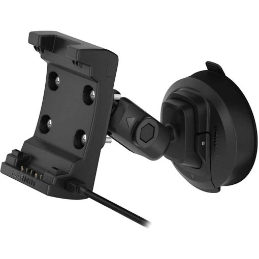
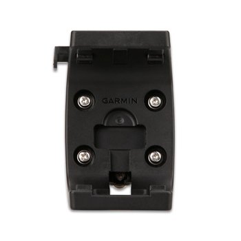
- Exclusive design: This rugged, water-resistant handset meets MIL-STD 810 for thermal performance, shock resistance, water resistance and vibration. It has a 5-inch gloved touch display and supports multiple rugged mounting options (sold separately) to accommodate all activities.
- TopoActive maps: Use preloaded topographic maps to navigate your adventures. View terrain contours, elevation data, coastlines, rivers, landmarks and more.
- Detailed satellite images: Download high-resolution satellite images directly to your device via Wi-Fi - no subscription required. View photorealistic aerial views of routes and surrounding terrain and easily create waypoints based on landmarks.
- Additional maps: Use the 32GB of internal storage to download additional maps, such as City Navigator® maps for driving or BlueChart® g3 maps for on-the-water navigation (sold separately).
- Outdoor Maps+: Purchase a subscription to Outdoor Maps+ (sold separately) to access a wide range of premium map content and receive regular updates sent directly to your handset via Wi-Fi.
- Garmin Explore™ app: Pair the handheld with the Garmin Explore app to plan trips, view trip data and also manage waypoints, routes and activities.
- Multi-frequency reception: Thanks to multi-frequency reception, the Montana 710 ensures precise positioning even in more difficult environments compared to using GPS alone.
- ABCsensors: With ABC sensors, including an altimeter for altitude data, a barometer to monitor the weather and an electronic 3-axis compass, you can navigate reliably in the terrain.
- Individual weather data: Access up-to-date, active weather forecasts via the Garmin Connect™ app on your compatible smartphone.
- Perfect dog tracking: For hunting and training, the Montana synchronizes with compatible Astro® or Alpha® series handsets to track sporting dogs in the field.
- Wikiloc Trails: This app allows you to download hiking and biking trails as well as other Wikiloc trails shared by other outdoor enthusiasts like you. Get a free 60-day Wikiloc Premium trial to test these and other exclusive features.
- Expedition mode: Cover long distances in the field. Use Expedition Mode, an ultra-low power GPS reference mode, to use the Montana for more than 2 weeks before it needs to be recharged.
- Extend battery life with batteries: An integrated lithium-ion battery pack delivers up to 24 hours of runtime in GPS mode and recharges with a standard USB-C® cable.
- Mount for boats, motorcycles and more: With a variety of mounts compatible with the Montana (sold separately), you can use the navigator with off-road vehicles, boats, cars, motorcycles, RVs or other vehicles.
Technical data of the Garmin Montana® 710
- Watch glass material: Chemically reinforced glass
- Dimensions: 8.76 x 18.30 x 3.27 cm
- Weight: 410 g with lithium-ion battery pack from the scope of delivery
- Water resistance: IPX7
- MIL-STD-810: thermal performance, shock resistance, water resistance, vibration
- Display: Transflective WVGA display with selectable orientation, touchscreen, display size: 6.48 x 10.80 cm, 12.70 cm (5-inch) diagonal, resolution: 480 x 800 pixels
- Battery: Rechargeable lithium-ion battery (included)
- Battery life:
- GPS mode: Up to 24 hours
- Expedition mode: Up to 440 hours
- Off mode: Up to 1 year
- Memory/protocol: 32 GB (the amount of memory available to users depends on the integrated maps)
- Interface: Compatible with high-speed USB-C and NMEA 0183
- Pre-installed maps: TopoActive Europe - additional regions can be downloaded via WLAN
- Options for adding maps
- Automatic route guidance (turn-by-turn directions on roads)
- Map segments: 15,000
- BirdsEye: directly on the device
- Includes detailed hydrographic features: Shorelines, lake/river shorelines, wetlands and permanent and seasonal watercourses
- Includes searchable points of interest: parks, campgrounds, overlooks and picnic areas
- National, state and local parks, forests and natural areas
- Storage and performance capacity: microSD™ card with a maximum of 32 GB
- Waypoints: 10,000
- Tracks: 250
- Track recording: 20,000 points, 250 saved GPX tracks, 300 saved FIT activities
- Routes: 250, 250 points per route; 50 points for automatic route calculation
- Rinex recording
- Sensors: GPS, Galileo, barometric altimeter, compass (3 axes, tilt correction), high-sensitivity GPS receiver, GPS compass (when in motion)
- Wireless connectivity: WLAN, Bluetooth®, ANT+®
Daily smart functions
- Connect IQ™ (downloadable display designs, data fields, widgets and apps)
- Smart notifications on the handset
- Weather
- Active weather data
- Compatible with Garmin Messenger app
- VIRB® remote control
- Compatible with Garmin Connect™ Mobile
Safety and tracking features
- LiveTrack
Tactical functions
- XERO™ locations
Outdoor leisure functions
- Point-to-point navigation
- TracBack®
- Area calculation
- Fishing forecast
- Sun and moon calendar
- Geocaching mode: Geocaching Live
- Compatible with custom maps: 500 user-defined map tiles
- Image viewer
- LED locator light
inReach® functions
- inReach® compatibility
Outdoor applications
- Compatible with the Garmin Explore ™ app
- Compatible with the Garmin Explore website
- Dog tracking: when paired with a compatible dog tracking system
Scope of delivery
- Montana® 710
- High capacity lithium-ion battery pack
- Charging/data cable (USB-C to USB-C)
- documentation

Fact Sheet
| Product Name: | Garmin Montana 710 Handheld Navigation Device |
| Manufacturer: | Garmin |
| Item Code: | GAR717766 |
| activity: | Cycling, Outdoor, Hiking |
| dimensions (l/w/h): | 88/183/33mm |
| IP rating: | IPX7 |
| transmission standard: | ANT+, Bluetooth, WiFi, USB, Wireless |
| expandable memory: | yes |
| internal memory: | 32Gb |
| Battery Type: | Custom Li-Ion/LiPo Pack |
| device functions: | Altitude, PC-/App-Analysis, GPS, Navigation, HRM optional, Cadence (optional or included), Temperature, Smart Notifications |
| Device Version: | Handheld |
| compass type: | electronical |
| Display Features: | Colored, Touchscreen, with Map Display |
| display size (diagonal): | 5" |
| Model year: | 2026 |
| Collection: | Full year |
| Color: | Black |
| weight: | 410g |
| manufacturer item code: | 010-02963-01 |
| Weight Source: | Manufacturer |
| GTINs: | 753759336868 |
| Manufacturer page: | https://www.garmin.com |
Availability
Ratings (0)
Manufacturer
Garmin
All products from Garmin
Garmin Deutschland GmbH
Parkring 35
85748 Garching
Germany
+4989 858364880
Parkring 35
85748 Garching
Germany
+4989 858364880